|


A few words about our plan as it stood when we left Kathmandu.
Our main problem is that because of the strikes and curfews, we
can't rely on starting or ending our trek with a long road journey.
We would have liked to travel by road to Dhunche or Syabru Bensi.
From Dhunche we could visit the lakes at Gosainkund. From there
we could walk north to the Langtang Khola, and then see how far
we could get upstream before heading back to Syabru Bensi, and taking
some form of road transport back to Kathmandu. Another variation
would be by road to Syabru Bensi, and then concentrate solely on
trekking up and down the Langtang valley.
It might be possible for a couple of trekkers to arrange some form
of transport, to sneak up to Dhunche, but that plan could fail at
any time, at a checkpoint or at an encounter with protesters. Because
we are camping, our group will number at least a dozen people so
keeping a low profile is just not an option.
Sundarijal, which is at the edge of the Kathmandu valley, just
north east of the city, is easy to reach by taxi with an early start
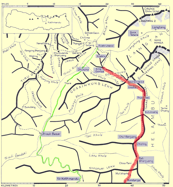
before the curfew. As you can see from the map above, starting from
Sundarijal, it should be possible, over a ten day trek, to reach
Gosainkund, and return by the same route . The route follows the
ridges mostly, which usually means spectacular views. There is an
added bonus in that if the strikes are called off at any time, we
can then extend our walking range, and return to Kathmandu by road.
<Next>
<Return to Nepal Page>
© Roy L Richards 2012
Contact for problems, queries etc:
|
Updated Jan 2010
|
|

|
|
|
|

|
|
|


