|


Jabal Ghawil Facts:
- AKA: - Al-Ain Alps, Swiss Mountain, The Grey Mountain.
- Altitude: - Camp-site is at 600m, summit is at 1100m.
- Round-trip: - Give youself 4.5hrs
- Difficulty:- Easy walking and easy scrambles up the gullies.
Take care if you choose the alternative descent because there
are some loose, steep bits that you need to avoid.
- Liz fear factor: - 2/10
- Chirri dog factor: - Not many goats or donkeys, but those
bat things are weird. A bit sore on my paws on the way down, and
not too much shade on a hot day.
- Dangers: - Don't take the alternative way down unless
you are confident of your route-finding.
- Wildlife and plants: - Caralluma Arabica in abundance,
and some fascinating bats in the cave.
- Navigation: - Ascent is very easy to follow. All waypoints
are WGS84 datum.
Introduction
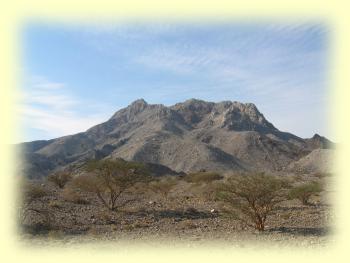
Jabal Ghawil is located amidst the Omani mountains, about 50 kilometers
north-east of the city of Al-Ain. Its distinctive light-grey colour,
which has led some some people to nick-name it the 'Swiss Mountain'
or the more imaginative 'Al-ain Alps', makes it stick out like a
sore thumb against the much darker opheolitic outcrops surrounding
it. The color makes it a great landmark. It also makes it easy to
find!
I only recently stood on Jabal Ghawil's summit, although it's been
helping me navigate for many years. While exploring the dunes east
of the Al-ain to Al-Hayer highway, or the wadis to the east of the
mountain itself; Jabal Ghawil has dutifully fulfilled the role of
waymark, and has saved me from getting lost on many occasions. I
knew it as 'The Grey Mountain', and although I've always been grateful
for its help in showing me the way, I was never really driven to
climb it.
From a distance, Jabal Ghawil is just not pretty; it looks more
like a slag heap at a cement works, than a majestic mountain beckoning
you to scale its slopes. I have to confess that I was wrong for
all those years, because now that I've climbed the Jabal, I've discovered
that it has hidden beauty. Just as you shouldn't judge a book by
its cover, so it is with mountains; not only do they appear differently
from different angles but also from different distances, and this
one is a whole lot better closer up!
First, I must tell you the story of how I came to climb Ghawil.
Many people contact me regarding information on my web-site, and
I'm always glad to receive feedback. What is especially good is
when someone tells me about somewhere new. In this case it was an
email from Chris Tourenq; thanking me for the information on the
web-site and paying me back with information on Ghawil. Chris didn't
know the name of the mountain, but was able to give me a GPS location
and a rough description of his climb. From then on it was inevitable
that I should have to go and take a look for myself.
 We
finally got to go in January this year (2004). Here is an excerpt
from my diary: "Had a brilliant camp and fabulous climb. Cool
on the summit at midday up at 1,100m. We came down via a different
route, making a nice circuit. 12° C at sunrise!" Short
and sweet, I know, but it reminds me of just how much we enjoyed
that day and of course how pleasant it is to climb when the temperatures
are so comfortable. We camped on the east flank of the mountain
which gave me a good close up view and left me in no doubt about
the route we would take on the climb the next morning. We
finally got to go in January this year (2004). Here is an excerpt
from my diary: "Had a brilliant camp and fabulous climb. Cool
on the summit at midday up at 1,100m. We came down via a different
route, making a nice circuit. 12° C at sunrise!" Short
and sweet, I know, but it reminds me of just how much we enjoyed
that day and of course how pleasant it is to climb when the temperatures
are so comfortable. We camped on the east flank of the mountain
which gave me a good close up view and left me in no doubt about
the route we would take on the climb the next morning.
For me, reaching the top of a mountain is always less important
than how it's achieved. Half the fun is finding a good route, and
in case you are in any doubt about what makes a route good, then
I'll explain that a good route is one that gets you to the top but
at the same time takes your mind off the inevitable hard work of
climbing. Slogging straight up a mountain whose summit never seems
to get any closer is not all that much fun; even though it's sometimes
unavoidable. Choosing a route that winds its way up narrow gullies
to the occasional pass with rewards of fantastic views, and which
then finally delivers you on the summit, seemingly much more easily
than you imagined, is my idea of hiking heaven. Luckily, because
you can't always guarantee these things, our route up Ghawil turned
out to be just great. The route took us up a series of short climbs
each ending at a col, providing ever more spectacular views, and
a welcome excuse for a rest.
To add to the interest there was plenty to see on the way too.
On the climb up from the second col, Chirri dashed off past me,
and up into a cave about 50 meters away. What then ensued can only
be described as pandemonium; blood-curdling screeches were emanating
from the cave that made me fear that he'd caught hold of some poor
creature and was doing it to death. Now, Chirri is not normally
a violent dog, but he is descended from a wolf and for all I knew,
instinct had taken over, and he was making a kill for the pack!
All very well, but we had plentiful supplies of fruit and munchy
bars for our summit snack, and definitely no need for fresh meat
or a bone to chew on.
As I approached the cave things didn't look good; there were bunches
of feathers and a detached bird's wing scattered around. When I
finally entered the large shallow cave, I found Chirri had merely
disturbed a family of about twenty bats. He was barking and trying
to climb the guano-covered walls, they were flying in and out of
the cave emitting high pitched squeaks. Fortunately the remains
of the bird that I'd seen were nothing to do with Chirri and were
probably left by a fox. Chirri eventually came to terms with the
fact that the cave walls were un-climbable and the bats realised
that they were quite safe in their lofty crevice. By the time Liz
arrived, relative peace had returned to the mountain.
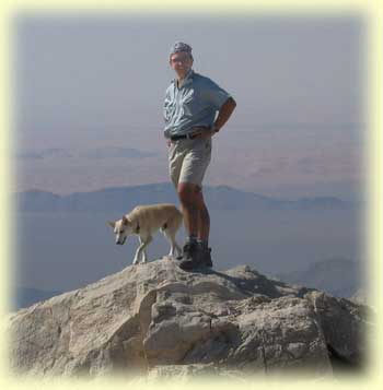
We eventually reached the summit at midday, and despite the overhead
sun, it was quite cold. The air was very clear and we could make
out Jebel Hatta and Jebel Sumeini to the north, and Jebel Hafeet
and Jebel Qatar to the south-west. We could see over to Buraimi
and Al-Ain and make out Jebel Jifra in amongst the dunes. Looking
over to the east we had great views of the impressive wadi systems
near Juwaif. At the foot of the mountain to the south-west we could
see where the grey rock of Ghawil butted up against the dark rock
of the small hills to the south. Jabal Ghawil drains into these
hills and has formed some interesting wadi systems. One particular
wadi, the largest one, looked like it would make a good hike and
you can read about that here soon.
From the main summit, and across a saddle to the west, you can
see another summit. Instead of making our way over to that, we decided
to make a circuit of the eastern side of the mountain by descending
the southern side to a large flat area. We then made our way down
the gullies to the east; finally returning to the camp by walking
north along a track along the eastern side of the mountain.
The descent was a little tricky in places but when I repeated it
a couple of months later I found a slightly better route. The easy
track back to the camp is a welcome break from the concentration
needed to safely descend the gullies. We arrived back at the car
in good time for a rest before making our way home. We left with
the feeling that we'd definitely be back. We returned in March to
repeat the climb with friends, and I returned in late May, to explore
the wadis to the south.
How to get to the camp
Click here
for maps
If you are coming from Abu Dhabi or Al-Ain, then you need to go
through Buraimi in the direction of the Sohar road, and then just
past the Buraimi Hotel, you turn left towards Mahda going past fossil
valley and Jebel Qatar. After passing Jebel Qatar on your right
and before reaching Mahdah, you turn left towards wadi Sharm, and
then go straight at the next roundabout towards Juwaif. After crossing
wadi Sharm you turn left at the next major junction in the direction
of Sumeini instead of continuing on to Juwaif. You should now see
the grey mass of Jabal Ghawil on your left. You'll find the turn
off to the camp on the left at 1.8km from the junction. This is
at waypoint N24°33.317´ E56° 3.080´ Take
care when turning off the tarmac because you are in a dip and can't
see oncoming traffic.
If coming from Dubai you can approach from the north by taking
the road to Hatta and then take the road leading south towards Mahda
which starts as the Hatta road passes Jebel Rowda. This is about
18km beyond the roundabout at Madam; there is a petrol station at
the junction. Continue south on this road towards Mahda, passing
Jebel Sumeini on your right. After 26km on this road you'll reach
a junction of roads and tracks but just continue on in a south-east
direction towards Mahdah. The track to the camp site is on the right
at waypoint N24°33.317´, E56° 3.080´
and about 15km from the junction.
The camp is at waypoint N24° 33.725´, E56° 2.686´
and to get there from the tarmac head directly towards the mountain
on a good track going north-west. There are a number of tracks going
off in different direction but ignore these. In less than 1km you
should come to a shallow wadi where the track appears to continue
north along the right side of the wadi. If you continue along there
you'll come to a dead end and have to turn back, but if you take
a good look at where the road first meets the wadi you'll see a
bumpy track which crosses the wadi. Go across the wadi and head
north along its west bank to the camp which is a flat area on the
right. There are other options for camping here depending on how
much space you need.
The climb
|
Camp to first col in about 30mins
|
|
To cave in 25mins
|
|
To second col in 10mins
|
|
To third col in 10mins
|
|
To summit in 35mins
|
|
Approx 2hrs to summit with stops
|
|
Descent 2hrs with stops
|
|
Round trip about 4.5hrs with time at summit
for lunch.
|
|
Summit waypoint : N24° 33.914´,
E56° 1.716´
|
 From
the campsite you can drive a little further north on the track squeezing
between a couple of acacia trees and over a couple of rises until
the track peters out. Here you can park the car out of sight and
get a little shade from a couple of trees. From
the campsite you can drive a little further north on the track squeezing
between a couple of acacia trees and over a couple of rises until
the track peters out. Here you can park the car out of sight and
get a little shade from a couple of trees.
Leave the car and walk along the wadi heading north and then north-west
until you get to a point where the wadi splits. Here you can see
the branch to the left goes up the interface between the light rocks
and the dark rocks. Don't take that branch but head up the next
gully to the right so that you have a ridge on your left between
you and the main mountain. There are vague goat and donkey tracks
to follow until you reach a col with great views into wadi Sumeini.
You should get here in under 30 mins.
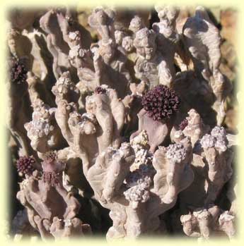
On the way up here and around the col look out for the khanasoor
plants which are abundant in the area. These are cactus-like, rubbery
plants, with thick grey-green stems about 30cm long. You may see
small maroon coloured flowers on the ends of the tips, with a shiny
white spot in the centre. This is Caralluma Arabica, a member
of the milkweed family and used by local people as a medicine. The
tips are apparently useful in treating indigestion so if your breakfast
is giving you problems then you know what to do!
From the col, turn left and climb up and over the ridge through
a small notch and then descend to a flatish area which is the top
of the other branch of the wadi. Here you need to climb up the rough
boulder-strewn gully ahead of you to the south west. After another
20mins or so you should see the bat cave in the cliffs to your right.
You can make a detour to it if you want. The last time I visited
it there were only a couple of bats in residence as opposed to the
twenty or more on my first visit.
Continue up the gully to the second col which is reached in another
10 mins. If you continued on here you would just descend, so turn
right and climb north-west up an easy gully to a small notch (third
col) on the ridge, in just a few minutes. Here you must scramble
up left and onto the ridge proper. You should now see the summit
just along the ridge in a west-south-west direction. Make your way
along the ridge dropping down from time to time to tracks along
the north side, and you should reach the summit in about 35mins.
When you approach the summit it looks like you'd need to do a bit
of rock climbing to get to the top because the face in front of
you appears pretty steep. Just continue on past on a path on the
right of the summit and look out for cairns that previous visitors
have left. Your aim is to go a little way past the summit and then
make an easy climb left up a gully. Once on the top walk back along
the ridge up to the summit. You'll know you are there from all the
goat droppings!
If you're lucky and it's a clear day, you'll have a wonderful panoramic
view of the surrounding countryside. Take a good look at the wadis
in the darker rocks to the south. I'll be writing about exploring
that area on another page. You should also be able to make out further
outcrops of the light coloured limestone running off to the north-east.
If you sit at the summit cairn facing the other subsidiary summit
30metres away to the west, then you should have steep cliffs falling
away to your left. If you look down there a bit to the right you
should see a flat area which can be reached by descending west down
a gully to the right of the subsidiary summit and then descending
on a traverse round to the right until you can find a gully to your
left which leads down to the flat area. Sounds a bit complicated,
I know, but you should be able to see the way down quite clearly.
Just don't try to head left down to the flat area too soon. If in
doubt, head back to the camp the way you came and don't risk a tricky
descent. From the flat area you have to work your way down and across
the gullies to the plains below where there is a track leading back
to the camp. Both ascent and descent should each take you about
2hrs with stops. Give yourself 4.5hrs for the round trip, giving
time on the summit to admire the views and to take lunch.
Have fun
Roy Richards June 2004
© Roy L Richards 2012
Contact for problems, queries etc:
|


